Clackmannanshire, often called the 'Wee County', is the smallest county in Scotland. With an area of 35,160 acres and population of 51,400 (2017 stats). Lying on the north bank of the River Forth, Clackmannanshire is bordered by Stirlingshire to the west, Perthshire and Kinross-Shire to the north and the Kingdom of Fife to the east.
The range of the Ochil hills form the county's northern border.
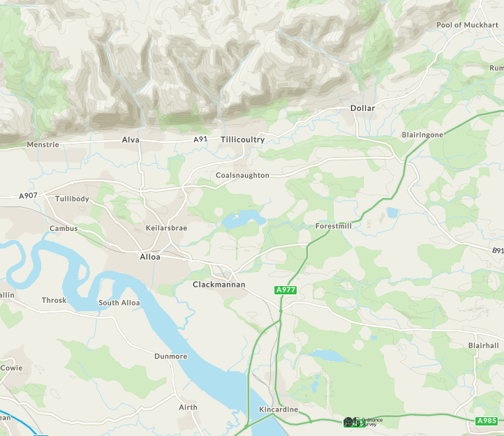
Clackmannanshire Ordnance Survey Map
Until 1822, Clackmannan was the County Town. Clackmannan was created a Royal Burgh in the mid-12th century in the reign of King David I. The now ruined Clackmannan Tower (formerly the Castle of Clackmannan), was a Bruce family property, the land on which it stands having been granted to Robert Bruce, a cousin of King David II, in the 14th century.
King Robert himself lived at Clackmannan Tower sporadically between 1316 and 1318 and visited this favourite hunting seat frequently until 1327. The early life of the tower as a royal hunting lodge ended in with its gifting to Robert Bruce in 1334.
Clackmannan's time of greatest prosperity was in the late 17th Century. Clackmannan harbour was situated where the Black Devon meets the Forth, but as the harbour silted up and the nearby port of Alloa expanded, Clackmannan's fortunes slowly declined. The Sheriff Court was transferred to Alloa in 1822 as Alloa became the county town.
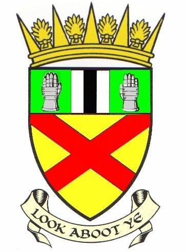
The motto on the County Arms is "Look aboot ye" - one story told about this is that when King Robert the Bruce lost his glove while out hunting near Clackmannan, he sent people to look for it with the instruction "Look aboot ye". The glove is said to have been found on the 'Look aboot ye Brae', on the south edge of Clackmannan.
Clackmannanshire's motto is "Look Aboot Ye" in Scots. It's 'Look Aboot Ye' on the County Arms as shown on some of the county's road signs. The latest version of which is shown below:
Towns and villages in Clackmannanshire
The larger ones are: Alloa, Tullibody, Cambus, Clackmannan, Kennet, Sauchie, Fishcross, Devonside, Coalsnaughton, Forestmill, Glenochil, Menstrie, Alva, Tillicoultry, Dollar, Pool of Muckhart and Yetts of Muckhart. There are many other hamlets and settlements around the county, many of which originated from mining works, mills, salt panning or distilling. Some have been demolished and only exist as area or field names. Farming has always been an important industry in the county, taking labour from all of the nearby villages.
Until the late nineteenth century, the county was comprised of only four parishes: Clackmannan, Alloa, Dollar and Tillicoultry, the parishes of Alva (previously part of Stirlingshire) and Muckhart (previously in Perthshire) only having been added since that time. Of the original parishes, Clackmannan and Alloa lay entirely between the two major rivers (Devon & Forth), while Dollar and Tillicoultry both extended south of the Devon.
Even before medieval times agriculture and associated industries were the mainstay of the local economy. However, families such as the Schaws of Sauchie and the Bruces of Clackmannan were already making a start on developing the local coalfields. As the medieval turbulence calmed and civil strife became less common, fortified towers such as those at Old Sauchie and Clackmannan began to be supplemented or even replaced by more open structures. Old Sauchie House, built 1631, was one of the first of these new estate houses and as the eighteenth century got under way, other structures such as Schawpark House, Tullibody House, near Alloa and Garlet House, near Kilbagie made their appearance.
By the end of the century these had been joined by Brucefield House, Kennetpans House and Kennet House. Tower Houses in Clackmannanshire were occupied by the Bruce, Erskine, Argyll and Schaw families. All of these families provided attendants for the Stewart Monarchs at their nearby seat at Stirling Castle. There were also other houses and castles in the county at Hartshaw, Alva, Menstrie, Tillicoultry and Dollar.
The eighteenth century in particular saw the semi-industrialisation of the countryside. New mills were also being established in the first half of the century.
The pace quickened after 1760, the Watermill Pit at Sauchie, sunk in the 1760's was notable for its waterwheel driven by a lade from Gartmorn Dam, a huge undertaking for the time. The collieries to the north of Alloa now began to be served by a network of waggonways leading down to the shore of the Forth, as did those south and west of the town of Clackmannan. It was in this same period that the shoreline itself began to be pushed back and the salt marshes west of Kennetpans were reclaimed for agricultural use.
The building of George Meikle's pioneering water powered threshing mill at Kilbagie in 1787 and the continual improvements in buildings over the remainder of the century were other tokens of agricultural improvement. Such setbacks as the closure of the Stein distilling enterprise at Kilbagie were balanced by developments such as the opening of the Devon Iron Works in 1792 and by the creation or renovation of woollen mills. The iron works not only made use of local resources of ore for the first time, but also gave a boost to the local coal industry.
To the north, along the ridges and slopes beside the Devon, the face of the countryside was changed by the development of smaller rows of houses and hamlets. In the far north, at Devonside, textile mills made their appearance. The area west of Alloa had still a very rural character but here the redevelopment of Tullibody early in the century and the slow rise of the tanning industry there brought change. By the middle of the century the new railways were beginning to link these areas together. The area of countryside east of Gartmorn Dam was the only area to remain relatively undeveloped.
Until the railways took over from ships for moving cargo around Britain, the River Forth had long been the main route to market for industry to the south and east of Clackmannanshire. The network of waggonways, roads or railways, have all played a part in linking the centres of industry to the main waterway.
The Earl of Mar's miners' cottages at Holton Square was the first of many colliery rows in the area, and by the mid 19th century, with the collected villages in the area becoming known as New Sauchie, now almost a suburb of Alloa.
Gartmorn Dam to the east of Sauchie is the oldest man-made reservoir in Scotland. It was created about 1713 by the Earl of Mar to provide waterpower, via a lade, to drain his coal mines locally. It is now also a county park and nature reserve, it's original use for mining having become obsolete.